.webp)


Bhubaneswar: After washing away the heat wave impact by rains due to a trough running from a cyclonic circulation over Madhya Pradesh, and the same converging with easterlies, it seems dynamic weather may take a twist in next 144 hours.
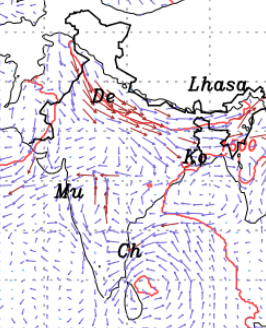
As per the model forecasts, a western disturbance will hit the states of Jammu and Kashmir, Ladakh, Himachal Pradesh on around March 26/27.
Winds from northwest will be sweeping the country from March 28 onwards. Moreover, by the end of March, an anticyclone area will develop over Bay of Bengal close to the Odisha coasts. The anticyclone is predicted to persist till April 2.
The above weather development will stop the sea breeze incursion into the land of Odisha. On the other hand, the State, especially the western parts, will come under the sweep of dry north westerly winds.
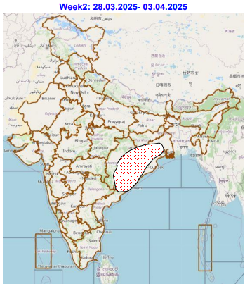
For which, the extended weather outlook of IMD has in its release on March 20 had predicted low to moderate possibility of heat wave over Odisha during the period of Marc h 28- April 2. (See the image below).
As a consequence, the day time maximum temperatures in all the western Odisha districts such as Nauapada, Bolangir, Kalahandi, Subarnapur, Bargarh, Sambalpur, Sundargarh, and other districts in the State like Angul in the central region and Nabrangpur in the southwest.
However, the costal districts in the State are unlikely to come under the heat wave sweep, when it returns from March 28 onwards.
MERCURIAL SHOW
The model forecasts by NCMRWF and IMD shows following districts may see mercury touching 40 deg C in March and overshooting it in early days of April first week.
1)Nuapada
2)Bolangir
3)Bargarh
4)Kalahandi
5)Subarnapur
6)Sambalpur
7)Deogarh
8)Angul
9)Boudh
Rest of the districts in the western and central Odisha will measure mercury at around 37-39 deg C.
However, the day time maximum temperature in the coastal, including Bhubaneswar, and southern districts, except Nabarangpur (a southwest district), will witness mercury ruling between 34-37 deg C.
.webp)