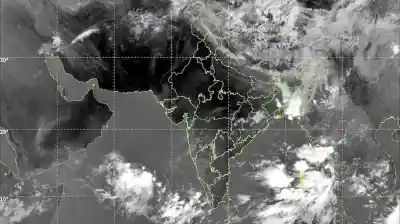
Under the influence of upper air cyclonic circulation over North Andaman Sea and adjoining east-central and southeast Bay of Bengal, the LPA is prominent over the sea, informed the Regional Met Center in Bhubaneswar.
The low pressure is very likely to move west-northwestwards and intensify into a depression by 22nd October morning and turn into a cyclonic storm by 23rd October over the Eastcentral Bay of Bengal, the Met department said.
Following deep depression, it is very likely to move northwestwards and reach northwest Bay of Bengal off Odisha-West Bengal coasts by 24th October morning, bringing heavy rainfall and gusty winds in both the states.
According to the forecast of IMD DG, Mrityunjaya Mohapatra, the courses of the Cyclone Dana will be more prominent on the characteristics of the low pressure area formed.
Under its influence, the sea conditions will remains rough. The wind speed along the Odisha coast may reach 40-50 kmph gusting up to 60 kmph from October 23 evening and will reach a speed of 100-120 kmph by October 24 night,the IMD DG added.