


Nation Navigates Early Monsoon and Active Weather Systems
India's weather landscape is currently shaped by significant meteorological developments, primarily the notably early arrival of the southwest monsoon over Kerala and an active depression in the Arabian Sea. These systems are ushering in substantial rainfall along the west coast, even as northern regions continue to experience heat wave conditions. The India Meteorological Department (IMD) has issued detailed forecasts and warnings, urging preparedness across affected areas.
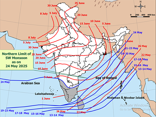
The southwest monsoon officially made its onset over Kerala on May 24th, a development occurring earlier than its typical June 1st arrival. This advance signals the beginning of the rainy season for the region. The monsoon has also progressed into other areas, including the remaining parts of the south Arabian Sea, sections of the west-central and east-central Arabian Sea, the Lakshadweep area, parts of Karnataka, the Maldives and Comorin area, much of Tamil Nadu, and portions of the Bay of Bengal and Mizoram. The northern limit of its current reach extends through Karwar, Shimoga, Dharmapuri, Chennai, and Saiha in Mizoram. Favourable conditions suggest further advancement into more parts of the central Arabian Sea, Maharashtra, Andhra Pradesh, Karnataka, Tamil Nadu, the Bay of Bengal, northeastern states, Sub-Himalayan West Bengal, and Sikkim in the next two to three days.
Compounding the weather scenario is a depression situated over the east-central Arabian Sea and the south Konkan coast. This system is projected to move eastward, crossing the south coastal Maharashtra by midday on May 24th. Its presence is a key driver for anticipated heavy to very heavy rainfall across the west coast—encompassing Kerala, Karnataka, coastal Maharashtra, and Goa—expected to persist for the next seven days. Specific alerts indicate the possibility of extremely heavy rainfall over coastal Maharashtra and Goa, as well as Madhya Maharashtra on May 24th. Similar intensity is forecast for coastal and south interior Karnataka from May 24th to 27th, and interior Tamil Nadu on May 25th and 26th.
While southern and western coastal regions prepare for intense rain, parts of northern India continue to grapple with high temperatures. Heatwave to severe heatwave conditions are predicted to persist over Rajasthan until May 27th, and over Punjab, Haryana, and Jammu & Kashmir until May 26th. A slight rise of about 2°C in maximum temperatures is also anticipated over northwest India in the next 24 hours.
The IMD's observed weather from the preceding period highlighted heavy to very heavy rainfall already experienced in Kerala, coastal Maharashtra, coastal and south interior Karnataka, Odisha, and Vidarbha, Maharashtra. Heavy rainfall was also noted in Goa, Bidar, Telangana, and Tamil Nadu. Thunderstorm activity was widespread, particularly in peninsular India, Maharashtra, and eastern Madhya Pradesh, with hailstorms in Himachal Pradesh and Uttarakhand, and a dust storm in east Uttar Pradesh.
Synoptically, beyond the primary monsoon and depression, cyclonic circulations are present over north coastal Odisha and Manipur, with additional circulations over western Rajasthan, northwest Uttar Pradesh, and Haryana, influencing local weather patterns.
The IMD has issued a series of color-coded warnings for the coming days:
The core message from the IMD is one of active and dynamic weather conditions across India. The early monsoon and the Arabian Sea depression are set to bring significant rainfall to the west coast and southern peninsula, necessitating caution and preparedness. Simultaneously, northern states must continue to manage heat wave conditions.
Source: IMD