

Kolkata, March 17: The All India Trinamool Congress (AITC) on Tuesday announced the 291 names of candidates for West Bengal assembly seats ahead of polling, which will be held in two phases on April 23 and April 29.
The vote counting will be conducted on May 4.
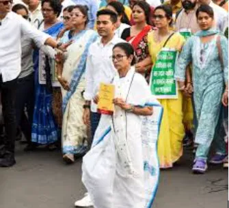
Addressing the press conferences, TMC chief Mamata Banerjee confirmed that they are giving three seats to their ally Bharatiya Gorkha Prajatantrik Morcha (BGPM).
The Anit Thapa party Bharatiya Gorkha Prajatantrik Morcha will contest from Darjeeling, Kurseong, and Kalimpong assembly constituencies.
West Bengal Chief Minister Mamata Banerjee will contest from Bhabanipur against Bharatiya Janata Party leader and Leader of Opposition in the Assembly, Suvendu Adhikari.
TMC Minister Chandrima Bhattacharya fielded from the Dum Dum Uttar seat, Trinamool Congress MLA Madan Mitra from the Kamarhati seat, Trinamool Congress Minister and Kolkata Mayor Firhad Hakim from Kolkata Port seat, Kunal Ghosh from Beleghata seat, and Dr Shashi Panja from the Shyampukur seat.
However, Former Education Minister Parth Chatterjee did not get a ticket from Behala Paschim and in his place, Ratna Chatterjee will contest this time.
On seat distribution, Banerjee confirmed, "Three seats TMC will not fight, we have discussed this with Anit Thapa. 291 seats TMC will contest."
Launching a sharp attack on the Bharatiya Janata Party and questioning its strategy ahead of the 2026 state elections, she alleged that the BJP has created an LPG gas crisis.
Banerjee said, "Before I announce the candidate list, I thank the people of Bengal. I dedicate Maa Maati Manush Banglar Sanskriti to all, and release the candidate list of 294 seats. I want to say something to the BJP - why are you afraid? Don't create a gas crisis if you want to fight; come to the ground in a proper way. ECI, you did a brilliant game... BJP has no chance. This time your seats will decrease as compared to the last time. This is the fight of Astitva of West Bengal. Bengal will win. 'Dilli ka laddu' will not win."
Banerjee also raised concerns over central administration in the state, claiming that all her power was removed by the BJP-led NDA government.
"All power of mine they removed. If there are any issues like natural calamities, who will take responsibility? If law and order issues arise, who will take responsibility? All my officers who are Bengali are removed, even non-Bengali officers like Vinit Kumar and Murlidhar. Central forces deployed - who will take their responsibility? Outsiders are here because they carry money. If anything happens here, don't blame me," she added.
Targeting Prime Minister Narendra Modi, Banerjee asserted, "In answer to PM, I want to say - we will win 2026 compared to the last election. Boycott the BJP, do not vote for the BJP. Vote for Bengal. In 2026, we will win by bagging more than 226 seats."
The TMC chief also urged voters to focus on regional identity over cash incentives, adding, "People should not vote for cash, people should vote for the Astitva of Bengal. We are confident we will win because we are the people of Bengal. They [BJP] have come here with planning, with arms."
The West Bengal assembly election will be held in two phases, with polling scheduled for April 23 and April 29. Counting of votes for both phases will be conducted on May 4. The election process is scheduled to be completed by May 6.
The last assembly election in the state was held in 2021, conducted in eight phases between March 27 and April 29, amid an intense contest between the ruling Trinamool Congress (TMC) led by Mamata Banerjee and the Bharatiya Janata Party (BJP).