



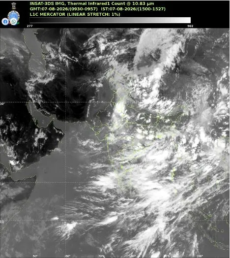
Dense ocean clouds lack clear triggers for heavy rainfall
Thick storm clouds are currently covering vast stretches of the equatorial Indian Ocean without bringing immediate rain to the mainland. Meteorologists note that while there is plenty of moisture waiting over the water, a clear weather trigger is completely missing. This means states like Odisha and other central parts of India must rely on existing weather patterns for their daily rainfall.
Satellite images reveal tall storm clouds
Recent thermal data from the INSAT-3DS satellite shows a huge band of clouds spread across the central ocean. These bright white formations reach chilling heights of 15 to 16 kilometres into the sky. Such extreme heights point to very active thunderstorms brewing far out at sea. Normally, this much ocean activity signals a strong monsoon push toward the Indian coast. However, experts explain that these systems are stuck south of the peninsula. Historically, the Bay of Bengal acts as the traditional nursery for monsoon depressions that directly water the croplands of Odisha and eastern India. Right now, this crucial bay shows no clear signs of forming a well-organised low-pressure system.
Also Read: Heavy Rains Trigger Red Alerts Across Odisha Weather Experts Warn of Coastal Winds
Current rain patterns and future triggers
States including Odisha, Chhattisgarh, Jharkhand, and Bihar are still getting widespread showers right now. This ongoing rain comes from active storm clusters moving along the normal monsoon trough. Weather experts call the current situation a loaded atmosphere. There is enough moisture ready to fall, but the spark needed to form a strong depression is absent. The ocean moisture is a very positive sign, though. If these clouds slowly move north, they could feed into the bay and start fresh rain cycles.
Distant typhoons block local systems
Forecasters are also keeping a close eye on Super Typhoon Dolphin far away in the western Pacific. Strong Pacific storms often change wind patterns across the entire globe. This distant typhoon might be stopping new rain systems from building up over the Bay of Bengal right now. Until a new low-pressure area forms locally, the most intense spells of seasonal rain will remain on pause.