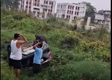
ଓଡ଼ିଆ | ENGLISH
ଓଡ଼ିଆ | ENGLISH

convert-tapaswini-express-to-lhb-design-coaches-pradhan

Published By : Bratati Baral | November 25, 2025 11:08 AM
convert-tapaswini-express-to-lhb-design-coaches-pradhan

Bhubaneswar, Nov 25: Weather models indicate the formation of a cyclone over the Bay of Bengal later this week. According to initial forecasts, a low-pressure area is set to develop over the South Andaman Sea on the 27th, which is expected to move west-northwest and intensify into a cyclonic storm over the South Bay of Bengal the same day. The system is then likely to curve northeastwards towards Bangladesh, weakening significantly over the sea before reaching the Bangladesh coast around December 2 or 3.

The India Meteorological Department (IMD) has predicted heavy to very heavy rainfall over the Andaman and Nicobar Islands until the 28th. However, no rain alert has been issued for Odisha, and the system is not expected to have any impact on the state, said Dr. Sarat Sahu, Director of the SOA Centre for Environment and Climate.

Meanwhile, a cyclonic circulation has formed over Comorin (Kanyakumari). IMD forecasts suggest that a low-pressure area will develop on Tuesday over Comorin, the adjoining southwest Bay of Bengal, and Sri Lanka, with the possibility of further intensification. The GFS model indicates that the well-marked low-pressure system over Malacca may move west-northwest and intensify into a depression by Tuesday.

Following its formation, the system is expected to shift northwestward before changing course towards the northeast and approaching the southern Bangladesh coast by December 2 or 3 in a weakened state. Another model, ECMWF, suggests that the depression expected on the 25th will move west-northwest and reach the South Andaman Sea before steadily weakening by the 29th.

Additionally, the low-pressure system developing over Comorin may intensify and potentially cross the South Andhra Pradesh coast around December 1, though it too is expected to weaken over the sea, according to multiple forecast models.