


Nation Prepares for Active Monsoon Conditions and Significant Weather Events
India is currently navigating a period of dynamic weather, marked by the vigorous advance of the Southwest Monsoon and forecasts for significant rainfall, particularly along the western coast. A recent briefing from the India Meteorological Department (IMD) on May 26th, 2025, detailed ongoing weather patterns and provided crucial outlooks for the coming week, underscoring the need for preparedness in several regions.
The preceding 24 hours had already set an active tone, with extremely heavy rainfall lashing parts of Konkan, Madhya Maharashtra, Kerala, Tamil Nadu, and South Interior Karnataka. Heavy to very heavy spells were also recorded in Goa and Coastal Karnataka, while areas as widespread as Bihar and West Bengal experienced isolated heavy rainfall. This activity is influenced by several prevailing synoptic systems, including a low-pressure area identified over Marathawada, various upper cyclonic circulations, and troughs extending across different parts of the Indian subcontinent. These systems are key drivers for the weather anticipated in the days ahead.
The forecast for the next six to seven days points to continued intense rainfall activity. The west coast, encompassing Kerala, Karnataka, coastal Maharashtra (including Mumbai), and Goa, is expected to bear the brunt of this moisture-laden system. Specifically, the IMD has highlighted the possibility of extremely heavy rainfall—exceeding 20 cm in some places—over Kerala, the Konkan region, the ghat areas of Maharashtra, and the coastal and ghat areas of Karnataka, particularly on May 26th and 27th. The ghat areas of Tamil Nadu are also likely to witness extremely heavy spells on May 26th.
Alongside this significant rainfall, temperature fluctuations are also anticipated. Maximum temperatures across northwest India are likely to see a notable decrease of 4 to 6 degrees Celsius over the next 24 hours, after which a gradual rise of 3 to 4 degrees is expected. Central India, meanwhile, is predicted to experience no significant temperature change in the immediate two days, followed by a slow increase of 2 to 3 degrees.
The IMD has issued specific alerts for May 26th, underscoring the immediate risks. A Red Alert is in effect for Madhya Maharashtra, Konkan, Goa, Coastal Karnataka, South Interior Karnataka, Kerala, and Tamil Nadu. This highest level of alert is due to the high probability of heavy to very heavy rainfall, with isolated instances of extremely heavy downpours. An Orange Alert, urging preparedness, covers Marathawada and North Interior Karnataka for heavy to very heavy rainfall. Gujarat and Bihar are also under an Orange Alert for gusty winds and a high likelihood of lightning. Further, isolated heavy rainfall is anticipated in the northeastern states, and strong surface winds are likely over Kerala. Thunderstorm and lightning activity is expected across most of the country, with the exception of Jammu and Kashmir.
Looking to May 27th, the intense conditions are set to persist. Isolated heavy to very heavy rainfall, with some extremely heavy spells, remains possible over the west coast, although Kerala might see a shift towards strong surface winds while North Kerala could still experience heavy to very heavy rain. Andhra Pradesh and Tamil Nadu may also receive heavy to very heavy rainfall, prompting an Orange Alert. The Red Alert continues for Konkan, Goa, Coastal Karnataka, South Interior Karnataka, and Madhya Maharashtra. Northeastern states and Chhattisgarh are also on watch for significant rainfall.
From May 28th, heavy to very heavy rainfall is forecast for the west coast, Tamil Nadu, and Telangana (under an Orange Alert). Odisha, Tripura, and Manipur could see heavy rainfall accompanied by hail. Northwestern states might experience isolated thunderstorm activity, with Himachal Pradesh and Rajasthan under an Orange Alert for strong gusty winds up to 50-60 kmph. The heavy rainfall is likely to continue over the west coast from May 29th onwards, with eastern parts of central and northwest India potentially seeing thunderstorm activity and heavy spells around May 29th and 30th. Rainfall is also expected to increase over northeastern states from May 29th, continuing with heavy to very heavy intensity until June 1st.
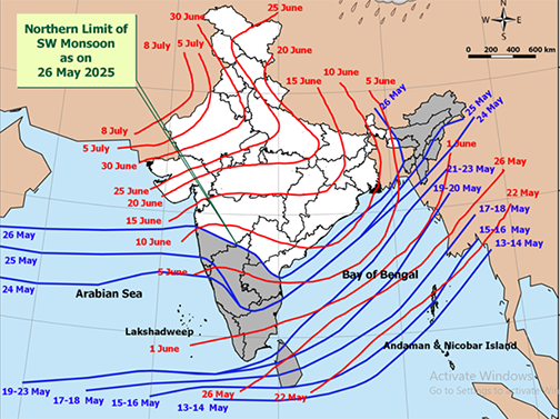
Crucially, the Southwest Monsoon has shown significant progress. As of May 26th, it has advanced further into more parts of the central Arabian Sea, much of Maharashtra (including Mumbai), Karnataka (including Bangalore), Tamil Nadu, Telangana, Andhra Pradesh, the west-central and north Bay of Bengal, and most northeastern states including Mizoram, Tripura, Manipur, Nagaland, Arunachal Pradesh, and parts of Assam and Meghalaya. Conditions remain favorable for its continued advancement over the next three days.
In light of these conditions, fishermen have been strongly advised not to venture into the east-central, west-central, and adjoining northwest Bay of Bengal, as well as parts of the south Bay of Bengal, the east-central Arabian Sea, Lakshadweep area, southeast Arabian Sea, and the Comorin-Maldives areas for the next five days.
The overarching message from the IMD is one of heightened vigilance and preparedness. With the monsoon actively progressing and several weather systems converging, significant rainfall and associated phenomena are expected across large parts of the country. Citizens are urged to stay informed through official IMD channels and take necessary precautions to ensure safety.
Source: IMD